Tactile Mobility Joins Forces with Major World Cities to Minimize Road Accidents this Winter
Road authorities and municipalities across the world are using Tactile Mobility’s in-vehicle software to collect road data in real-time, enabling safer roads
[Haifa, Israel, February 11, 2021] – Tactile Mobility – the leading tactile data and virtual sensing technology company for the automotive industry, municipalities and road authorities, insurance industry and more, is joining forces with cities across the globe, in Israel, Singapore, the United Kingdom, the Unites States and more, to ensure safer roads, and by extension safer cities, during the upcoming winter months. This winter, Tactile Mobility’s tactile sensing and data technology – which enables road condition maps of pavement conditions, road slipperiness (grip estimation), distress locations and more – will greatly enhance vehicle safety, road asset management and road safety, all at a fraction of the cost of existing methods.
Many cities across the globe suffer from poor road conditions due to inclement weather during the winter months, from slippery roads and black ice to aquaplaning and pavement deterioration. Today, many cities rely on outdated, expensive practices to monitor the condition of their roads – namely via survey vehicles, ‘manual’ citizen and municipal/road authority reports and more. Many do not have the appropriate measures in place to keep their roads monitored at an adequate frequency to support adaptive maintenance, especially when winter takes its toll. Tactile Mobility’s tactile sensing and data technology enables cities to generate real-time tactile data, insights and maps that inform the prediction of upcoming grip risks and improve road safety by monitoring and measuring how roads experience different weather and atmospheric conditions.
“Tactile Mobility is enabling safer roads by equipping cities and vehicles on the road with the insights that they need to conduct responsive and preventative road maintenance and ensure safer roads for their citizens,” said Eitan Grosbard, VP of Business Development at Tactile Mobility. “With tactile insights displayed on crowdsourced real-time maps, cities have the tools they need to improve highway exits and entries and live hazard detection, come rain or shine. This minimizes dangerous areas due to inclement weather, infrastructural problems and road hazards as well as cutting city costs and saving lives in the process.”
“Tactile Mobility is bringing state-of-the-art innovation to Yorkshire, equipping us with 24/7 data and insights regarding pavement ratings, pothole locations and much more,” said Nigel Yeatman, Highways Asset Manager at A-one+. “With these tactile insights, our contract will be better equipped to make decisions which affect preventative and ad hoc road maintenance and repair – minimizing the risk of road hazards as well as keeping the roads safer and well-maintained.”
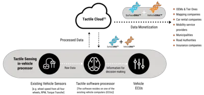
The company utilizes vehicles’ existing built-in sensors (wheel speed, wheel angle, RPM, brake pedal position, etc.) to create actionable insights regarding the roads as well as the vehicle-road dynamics. Vehicles embedded with Tactile Mobility’s technology collect and analyze vital road condition data which is transformed into SurfaceDNA™ in the cloud. SurfaceDNA™ models road features such as grades, banks, curves, normalized grip levels, and the location of distresses such as bumps, cracks, and potholes.
Cities visualize SurfaceDNA™ insights in the form of comprehensive, user interface (UI), crowdsourced tactile maps that offer a real-time view of driving environments – as they pertain to Available Grip Level Estimation. The maps can be used by control rooms, highway authorities, the Department of Public Works, and other city departments to identify and respond in real-time to the level of grip on the road, affected by road slipperiness. Tactile Mobility also provides retrospective grip maps which give cities access to all the accumulated data in the system over time, enabling them to evaluate road behaviors across different weather scenarios; with access to these maps, cities can find and analyze hot spots which create risks for drivers and subsequently take the appropriate action.
SurfaceDNA™ insights are not only visualized on Tactile Mobility’s UI maps, but they’re also transmitted to vehicles that house Tactile Mobility’s embedded software, strengthening their vehicle control and ADAS systems and providing them with real-time insights regarding the road ahead. Such insights can drastically improve vehicles’ Available Grip Level Estimation and promote improved braking and adaptive, predictive cruise control – the latter of which enables vehicles to decelerate based on road distresses as well as low grip level on dangerous, slippery winter roads.
Tactile Mobility recently joined forced with the City of Detroit and a major Detroit-based Automaker, with the support of Planet-M, to conduct a proof of concept which demonstrates the power of tactile technology. Equipped with tactility, Detroit and other cities alike can detect areas of slipperiness such as ice, water, or additional weather-related elements in real-time and transmit the information to control centers that will alert drivers before reaching such suspected areas. POCs such as this one mark the beginning of a new era: cities now have access to a full suite of solutions that provide insights about maintenance and road safety.
About Tactile Mobility:
Tactile Mobility is the world’s leading tactile virtual sensing technology and data provider, enabling actionable insights for autonomous vehicles, municipalities, and fleet managers. Tactile Mobility’s unique technology collects “first principle”, crucial, anonymized real-time data generated from vehicles’ non-visual, existing sensors and turns it into actionable insights on road attributes including grades, grip, and curvatures as well as vehicle attributes such as weight, tire parameters, and more. Insights provided by Tactile Mobility greatly enhance vehicle intelligence and ride safety, efficiency and experience as well as empower city officials with new and much higher value data to better conduct planned maintenance and detect hazards in near real-time. Tactile Mobility was co-founded in 2012 by Boaz Mizrachi, Yossi Shiri, and Alex Ackerman. The company is already working with multiple OEMs, road authorities, and municipalities and is based in Haifa, Israel with a presence in Europe, the US, and Asia.


