

Google Maps To Add RR Crossings
 |
by Marty Bernstein
Senior Editor-at-large
The Auto Channel
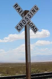
Nearly 250,000 railroad crossings (also known as grades), the intersection of train tracks and roads, blanket the U.S. But even with the easily recognized warning signs and devices, 270 people were killed and over 800 more were injured at crossings resulted from almost 2,300 accidents. An increase over last year, the first in a decade.
 |
Shortly after joining the FRA in January, Sara Feinberg, the acting administrator of The Federal Railroad Administration (FRA) of the Department of Transportation, the government agency responsible for all things railroad, decided to do something about these deaths that early on resulted in a surge of rail crossing incidents.
In her leadership role, Ms. Feinberg pro proactively approached Google, to see if they would partner with the FRA to integrate the specific locations of every rail crossing across the nation adding audio and visual alerts onto Google Maps with its turn by turn directions.
Ms. Feinberg commented, “The vast majority of these rail crossing accidents and deaths are preventable. They are frequently the result of a driver’s lack of awareness of a crossing or an oncoming train, or a driver’s attempt to beat the train. Each one of these deaths and injuries is heartbreaking. We can –and should—do everything possible to end vehicular-train incidents at rail crossings.”
Google agreed enthusiastically to partner with the FRA. The Silicon Valley behemoth will use the FRA’s data to pinpoint the location of almost every rail crossing in the United States in its Google map turn by turn instructions. A Google spokesperson told me, “We’re happy to help the Federal Railroad Administration as we’re always looking for new ways to make maps useful to our users.”
 |
On a personal note: I had friends many years ago who lost a son in rail crossing incident. Hopefully with the addition of alerts to maps the tragic deaths will be significantly reduced. Feinberg also reached out to other map makers including Apple, MapQuest, Garmin and Tom- Tom to partner with the Federal Railroad Administration in developing map alerts.
No word as to what the audio alert will be, but loud train whistle wouldn’t be so bad would it?